"I'm going to build my secrets into the Geometry of these buildings, because I know that books can be burned but buildings not so easily."
- Thomas Jefferson
UPDATED: 04/08/2014
Introduction
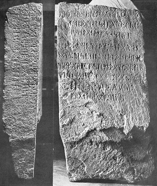
The Kensington Runestone has been the subject of discussion and controversy since its discovery in 1898 by a Swedish farmer, named Olof Ohman, while clearing land for his farm near Kensington, Minnesota (45* 48' 46.17"N - 95* 40' 01.53"). Due to inherent skepticism, and the fact that Olof was himself Swedish, many people thought the stone was a forgery. This controversy has existed for over 100 years up until this very time. Well the controversy is over. There is now physical proof that the runestone is authentic and plays a large role in American history. The Kensington Runestone, pictured above, is 31 inches high, 16 inches wide, six inches thick and weighs 202 pounds. On the face and one side are characters known as "runes", a type of writing used in the Middle Ages only by inhabitants of northwestern Europe, such as the Norwegians, Danes, and Gotland Islanders.
Geoglyphology
The information gathered for presentation on this website was gathered using a new technique called Geoglyphology. (Google keyword: Geoglyphology). The calculations performed on both this website and the Newport Tower website require the use of a special software called "Google Earth". Google's software is able to calculate true spherical bearings on a curved surface and then display them correctly on a flat plane. This software can be acquired, free of charge, by searching the internet using the keywords "Google Earth".
The function of Geoglyphology, as it relates to Archeology, is to expand both the search area and the knowledge base available to the Archaeologist.
Until now the majority of the information available to the Archaeologist is gleaned from the information recovered at the dig site. In recent years it has been discovered that a great majority of the ancient architectural, monolithic and geoglyphic structures built around the world have something in common. That commonality is that the structures were aligned in such a manner that the study of their linier alignment unveils a much larger story and immensely expands the data available to the archeologist and the related disciplines.
Data recovered from sites, that included Geoglyphology in their study, included obtaining the geographical range of the culture being studied, the level of sophistication that existed in relation to their understanding of mathematics and geometry, their knowledge of world geography, the discovery of other archeological sites that were unknown prior to the studies, and the dating of the culture itself by the data collected at related offsite locations which were identified by the alignments at the dig site.
The success of these studies shows that Geoglyphology can play a major role in expanding the knowledge base available to the Archeologist. The protocols used to determine the termination points of the radials are not included in this article, but were established over 10,000 years ago and only recently rediscovered.
The Kensington Runestone
If you visited the Newport Tower website ( Newport Tower Link ) you will understand how the Kensington Runestone fits into that puzzle. As the Newport Tower was used to establish the location of one of the most important locations of the early inhabitants of North America (Inspiration Peak), the Kensington Runestone is used, to not only locate and validate that same location, but to describe new boundaries for the North American Territory for which Inspiration Peak is the central survey marker. As has been said many times, the builders of these markers never provide only one solution to a puzzle. There are always one or more other solutions to prove the first.
The Kensington Runestone Solution
As you learned in the Newport Tower presentation the Newport Tower lead us to two important geographichical, and historicly important, points. One was Inspiration Peak, MN USA and the other was the Kensington Runestone location in Kensington,MN USA. As you will see, these three geoglyphs are tied together to outline an amended North American Territory which was again amended by the "Treaty of Hidalgo" after the Mexican American War.
Runestone Front
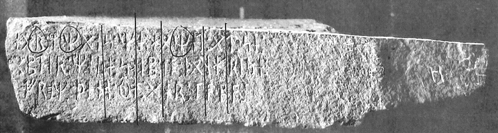
Runestone Side
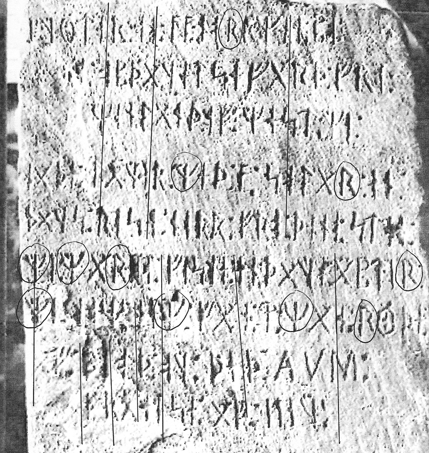
Upon submitting the runestone to a handwriting analysis it was determined that the writing had been done by two different persons. The first five rows were done by one person and the last four rows, and side, were done by a second person. The first tip off is the slant of the work. If you will check the slant in the pictures above you will notice a distinct difference from one persons writing to the other. Another tip off is the way the letters are formed. For example; the first person brings the right leg of his "R" all the way down to the baseline, the second person stops short of the baseline. As is common when someone is attempting to copy another persons writing, the first half of the sixth line is similar to the first five lines. But as is always the case, the copier gets tired of trying to copy the other persons style and towards the end of the first line and thereafter he reverts back to his own style. It is believed that the second persons writing was added to redefine the boundaries of the North American territory after Cortez invaded Mexico in 1519 and claimed Mesoamerica for Spain. As is depicted in the Newport Tower solution, Central America was once part of a North America land claim.
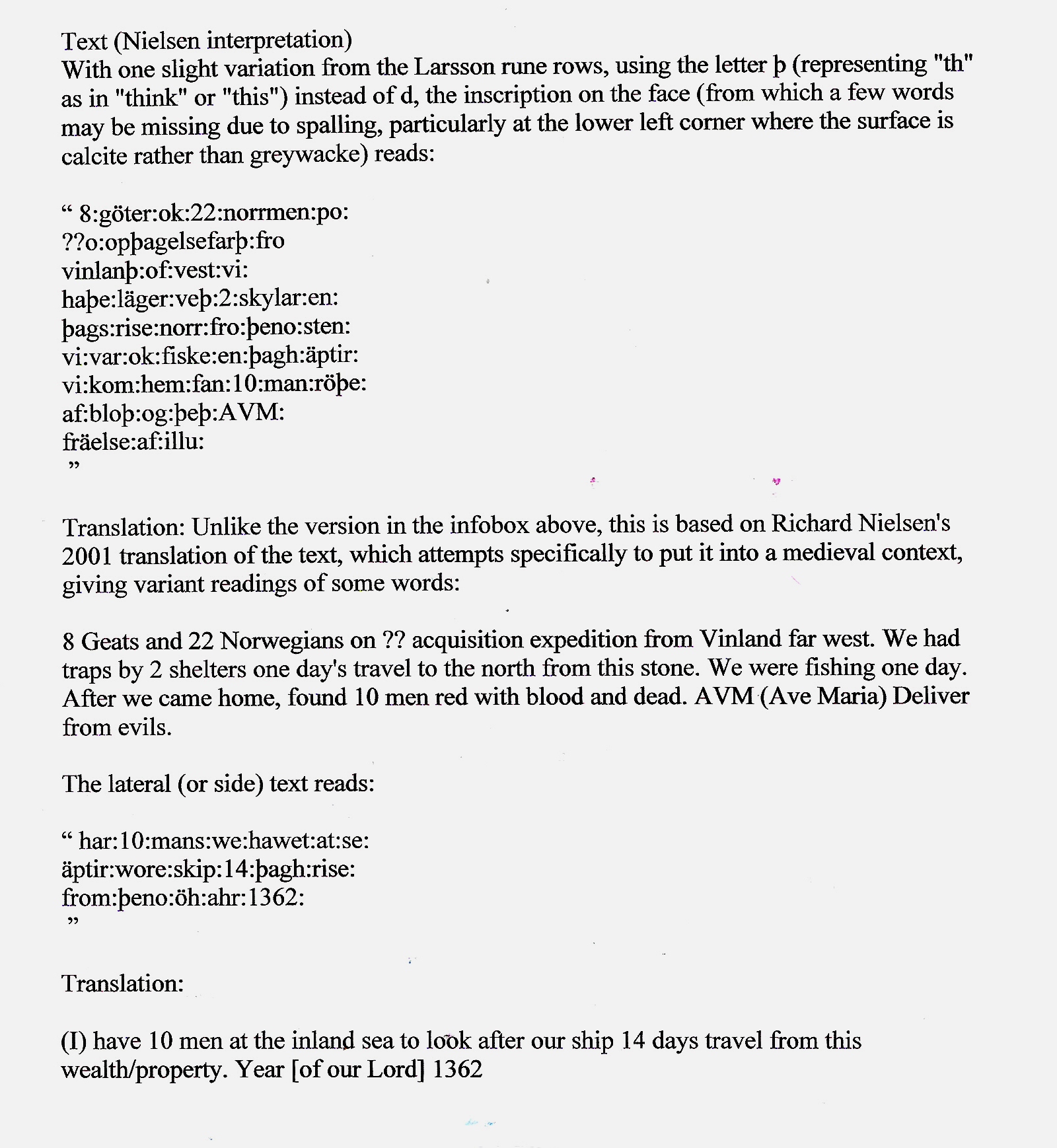
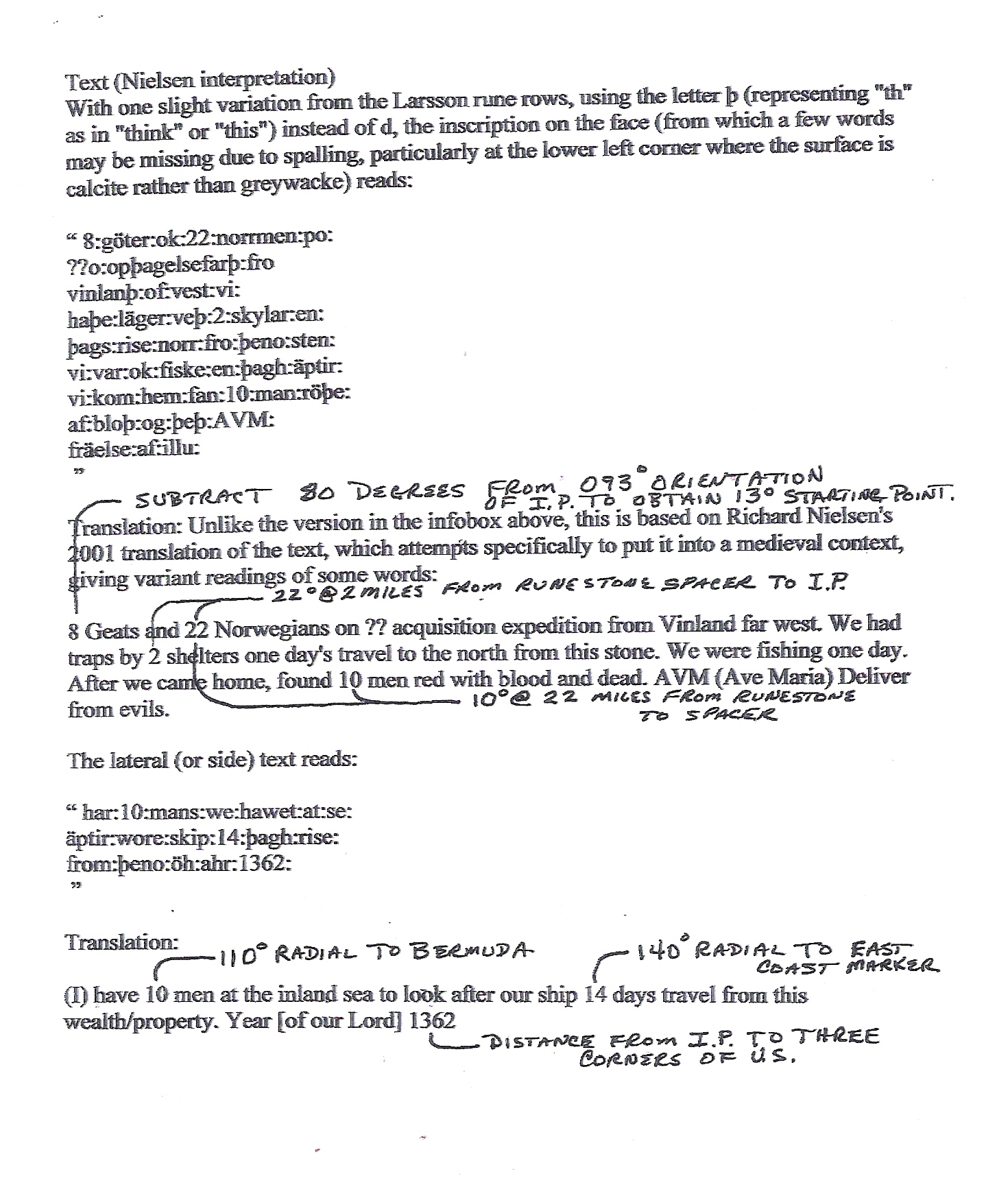
Nielsen's Translation
In order to discover how the runestone and the tower were connected it would be necessary to study a translation of the Runestone done by Dr. Richard Neilsen. As previously stated, the builders of the Newport Tower and creators of the Kensington Runestone have little use for words and place most of their emphasis on numbers, geometry and symbols. Attention was directed to the numbers contained in the translation. The above translation is the original translation by Dr. Neilson. The decoded version follows below.
Translation Decoded
010 Degrees at 22 Miles
One solution derived from the numbers given on the runestone was a heading of 10 degrees at 22 miles. Although this interpretation seemed to be headed in the right direction it still did not give any indication that it was a correct solution to the puzzle. Neither did any of the other combination of numbers. Research was done to see if the method of measurement had changed from 1362 until now. Sure enough Queen Elizabeth had changed the Universal Standard of measurement, the mile, from 5000 feet to 5280 feet, in 1592, after becoming Queen. That meant that 22 miles in old English miles would convert to 20.8 miles in new English miles. Curiously enough most of the explorers maps that have been discovered are dated in the 16th Century. Could this change in universal measurement have come about to mask all the measurements done before that?
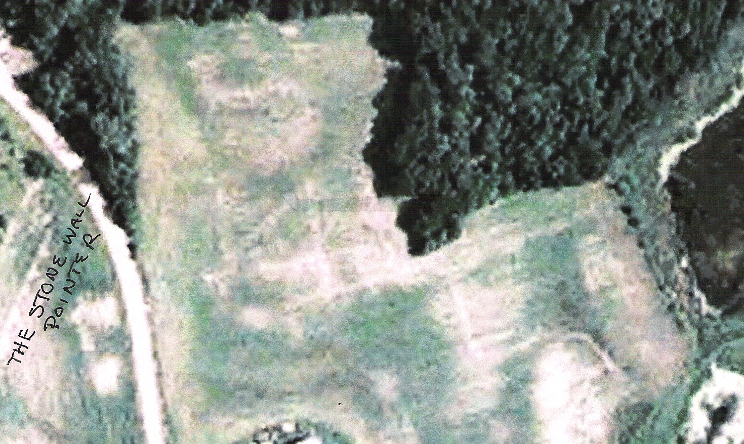
The Spacer (46 06 33.05N - 95 35 05.68W)
After converting the English miles the figures 10 degrees at 20.8 miles were used which placed the end point on what became known as "The Spacer". It was called this because the measurements are so precise that when you land on the south end of the spacer, and begin your second leg from the south end, you will come up short of reaching the all important Inspiration Peak, by the same length as the spacer. The second leg of the connection must start on the north end of the Spacer. The "Spacer" is the line on the left side of the picture, which looks like a runway. This is in reality a stone wall that someone has mowed around.
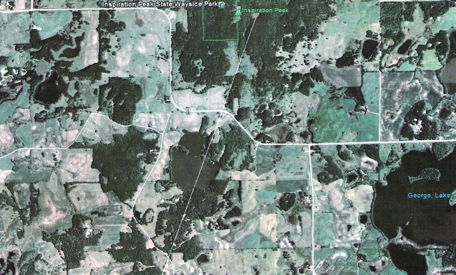
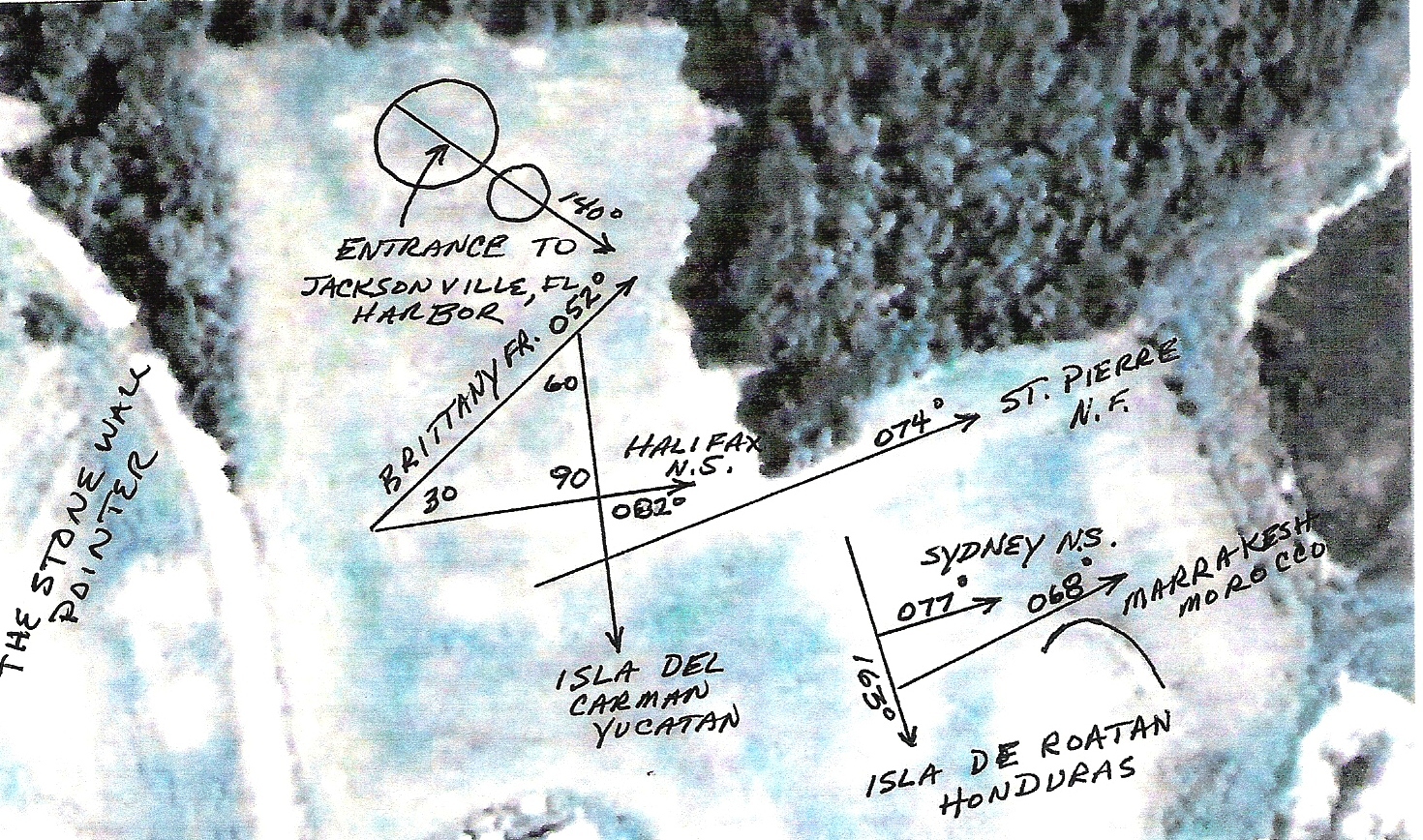
Inspiration Peak - 22 Degrees at 2 Miles (46 08 09.49N 95 34 14.61W)
Now that the Spacer has come into play one must follow the new direction, to which both the Stone wall points at 22 degrees, and which the Kensington Runestone describes as 22 degrees at 2 miles, to reach the main survey marker named Inspiration Peak. But remember, we are dealing in old English miles so the real distance is 1.9 miles. The end of the last line drawn lands precisely where the West vertex of the Newport Triangle solution landed.
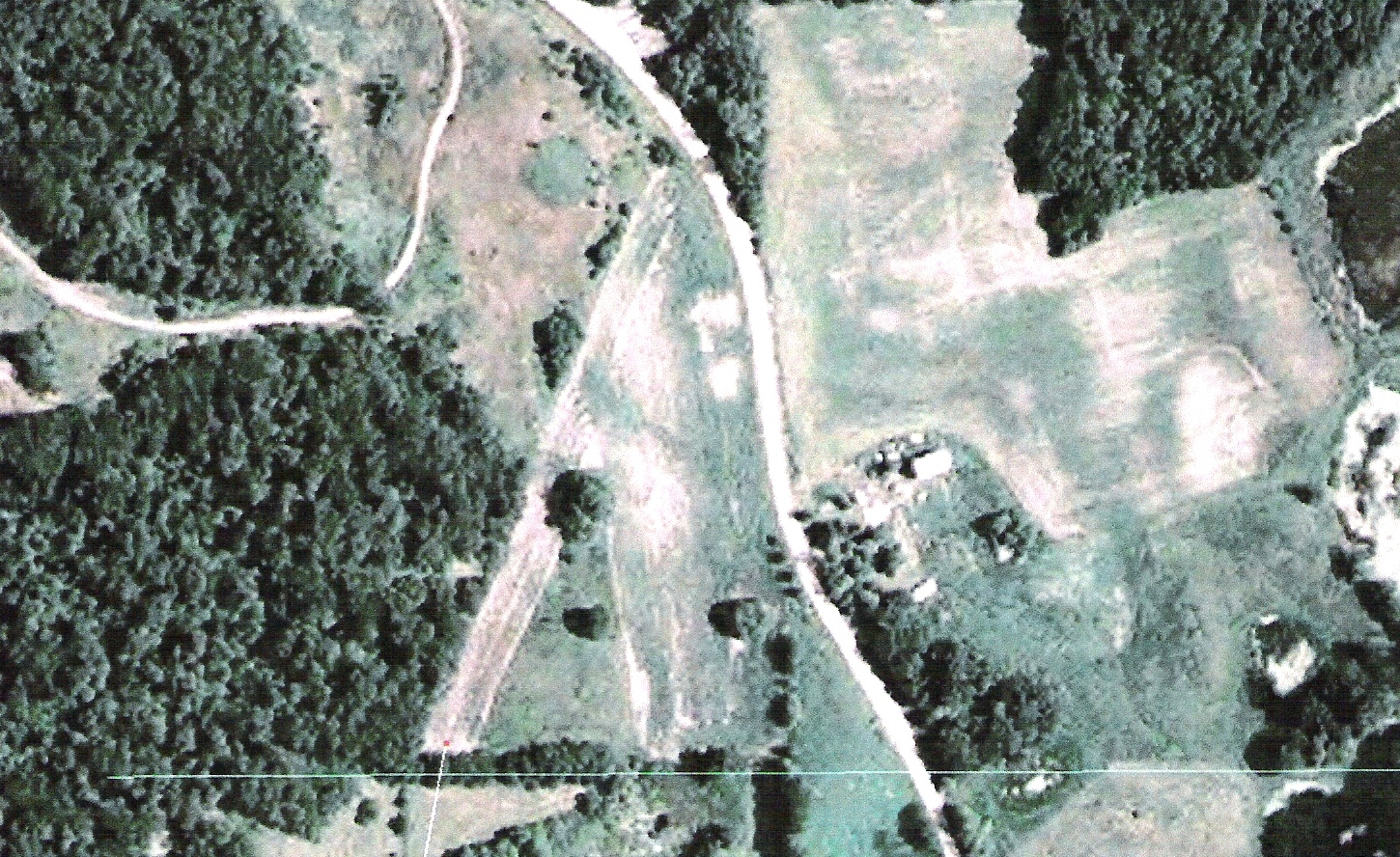
THE CAMPSITE
The figures displayed above are the figures used to transition from the place where the Kensington Runestone was found, to "Inspiration Peak". However, locating Inspiration Peak was meaningless unless you already knew the geometry associated with it. It appears that the first writer assumed that the reader would already know the geometry and would only need to locate Inspiration Peak in order to apply the mathematics. There was enough information in the first five lines of the text to locate the "...traps and two shelters one day north from this spot." (This is referring to a campsite containing the stone wall pointing to Inspiration Peak. This campsite is depicted in the next two photos.) However, the second writer had a different agenda and wanted to make the complete solution available to whoever might find the stone. This would be a prudent move if the second writer assumed the details would be lost to time. But this was not the only reason for placing new information on the stone. Since the time that Inspiration Peak was surveyed, thousands of years before, things had changed that required a revision of the boundaries that had existed for millennia. The main reason for the revision was the capture of Central America, originally part of this land survey, by the Spanish in 1519. (See photo titled "Revised North American Territory" below)
Since the time the Kensington Runestone was first carved (c1362) the Northern Territory had changed. The territory in its original concept included Meso (Central) America and Baja California. In 1519 Hernando Cortes invaded Mexico City and claimed that land for Spain. The New England inhabitants at the time were still too weak to challenge Spain in this action. This required an alternative plan. It is believed that this is why the second carving, and the Southern 1362 mile long radial, defined by a geoglyph in Southern Texas, was placed on the stone. This was a quick and easy way to modify the original land claim to fit their current situation.
The critical addition to the Kensington Runestone was the number 1362. As you will see, although further investigation has confirmed the original date of 1362, the 110 degree radial and the 140 degree radial were also added and are also critical in solving the revised puzzle. The new information was a crucial part of revising the ancient survey done in North America thousands of years before. The revised North American survey excluded Central America and retained Baja California. Unfortunately Baja California was later lost in treaty negotiations after the Mexican American war.
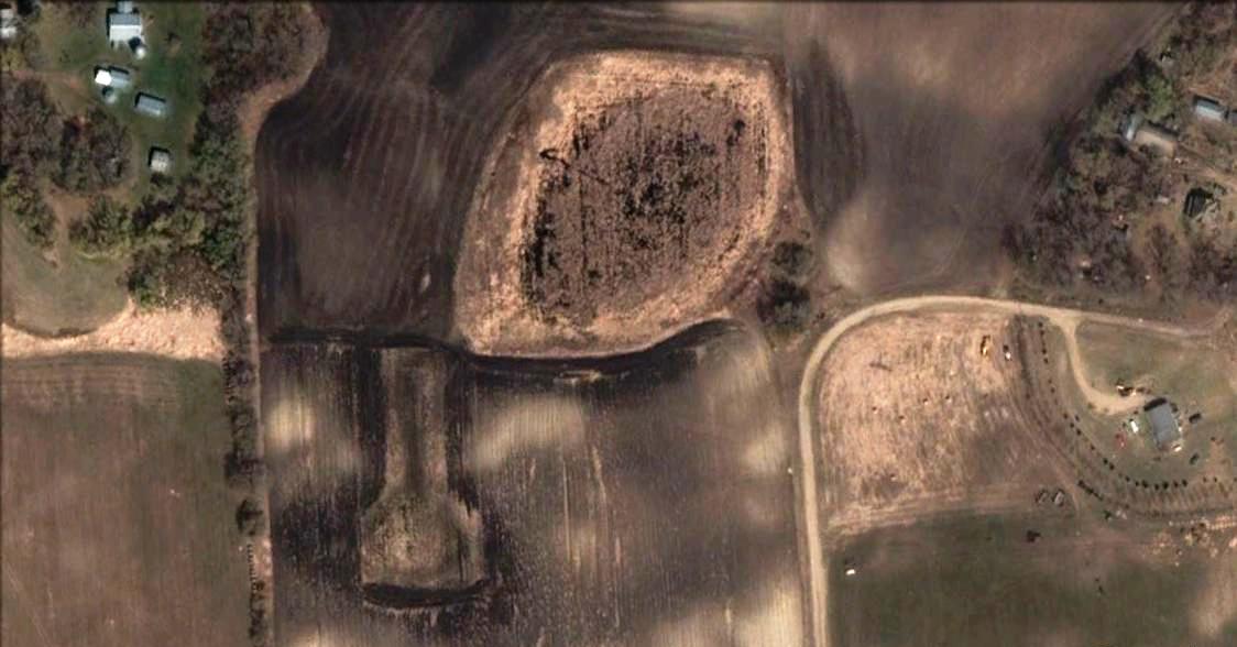
Campsite One Day North of Kensington Runestone Site
NOTE: This photo is presented so that you could see the geoglyphs on the ground before they were covered with lines in the next photo.
Campsite With Geoglyphs and Stone Wall Pointing to Inspiration Peak
This campsite is obviously the one mentioned in the first five lines on the Kensington Runestone. The stone wall here is oriented 22 degrees at 2 miles from Inspiration Peak. All that would be necessary from here is to follow the stone wall pointer, a common pointer in Geoglyphology at the time, to Inspiration Peak. The Pre-Columbian geoglyphs confirm this was a campsite, as placing geoglyphs at your campsite to claim a territory, or denote your travels, was a common practice. The radial endpoints shown in the photo are all known, Pre-Columbian, geoglyphic locations. The lines that are generated by this geoglyph, unlike most, do not seem to form an organized territorial boundary. The lines may be the countries of origin of the men mentioned on the Kensington Runestone. As you will see below on the Spirit Pond Stone, the Nordic crews were comprised of men from many ports of call.
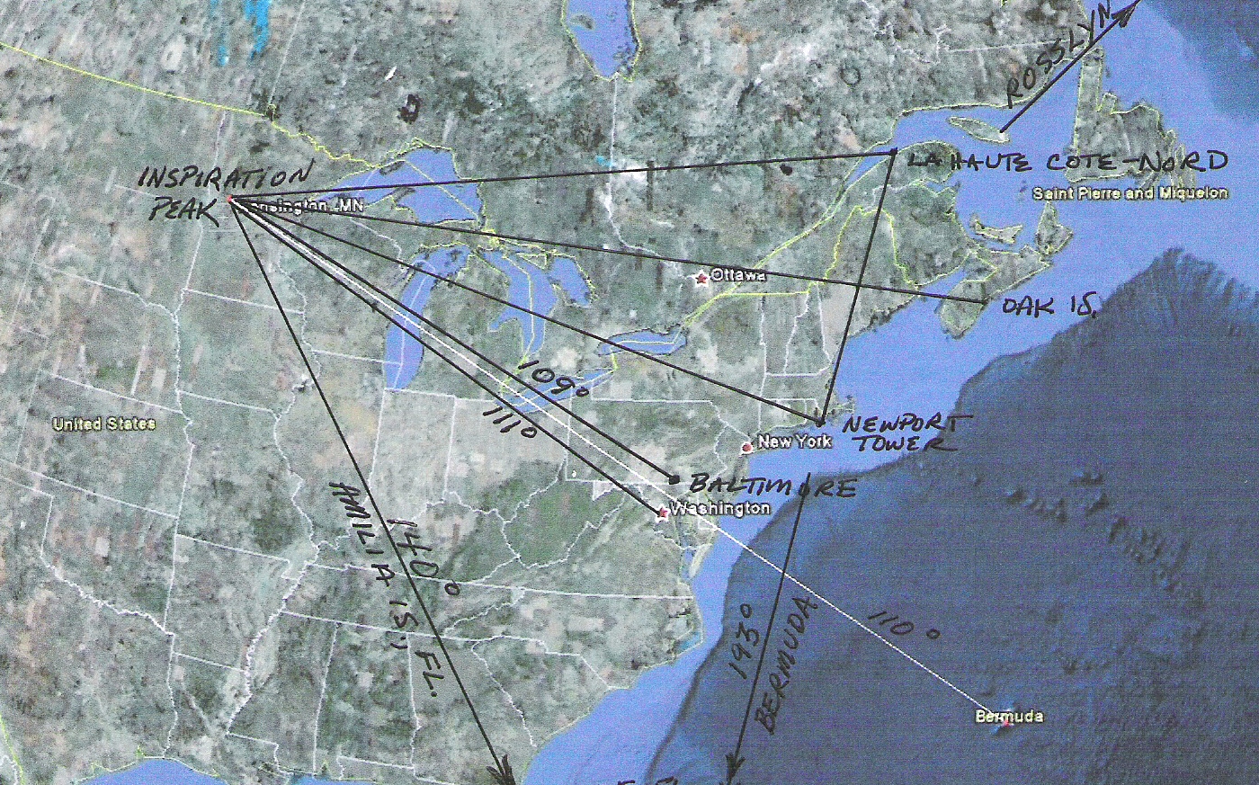
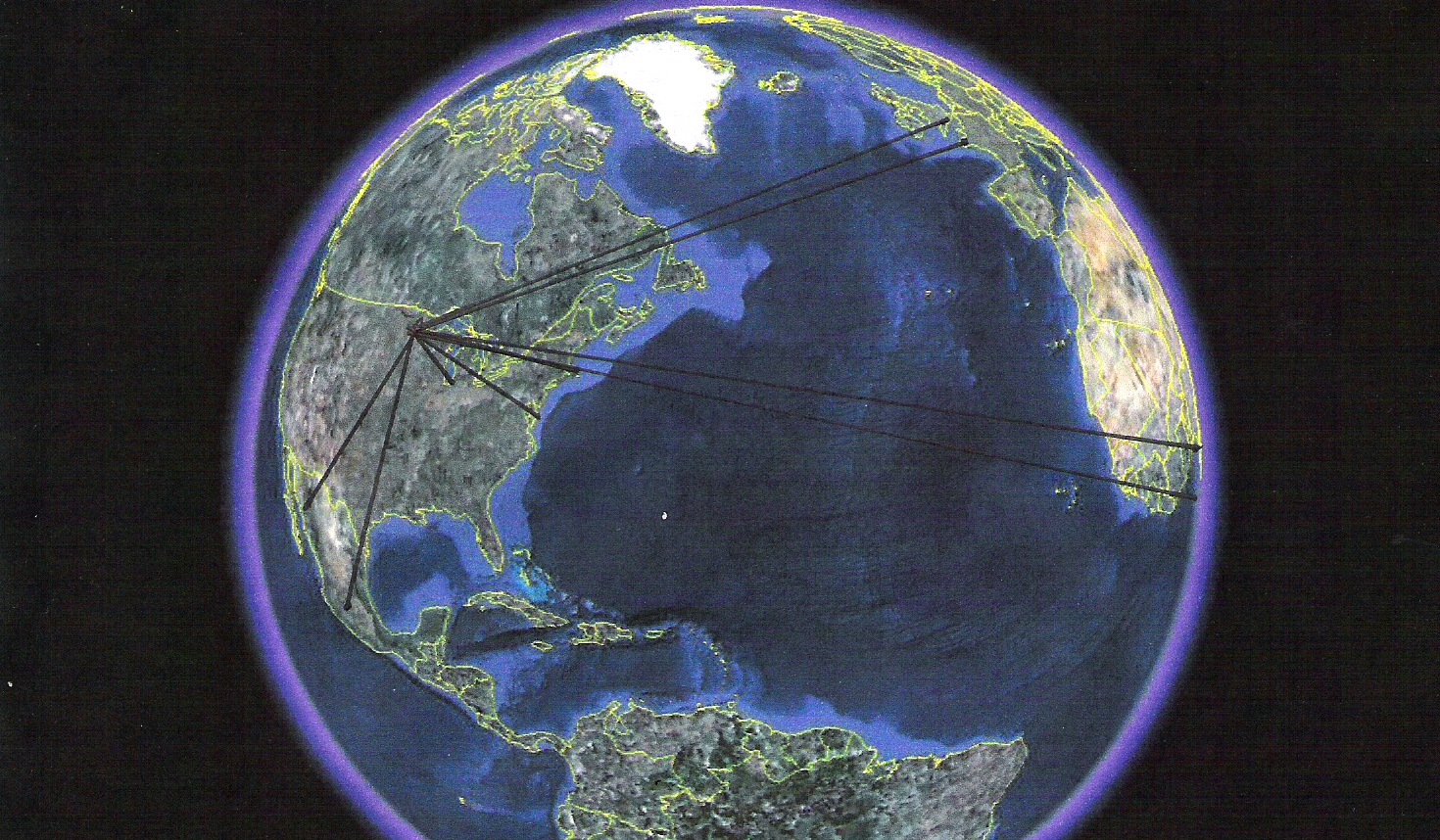
Inspiration Peak 110 and 140 Degree Radials as Defined by the Kensington Runestone. (The other lines are added for relationship purposes)
Revised North American territorial boundaries as described by the
Newport Tower, Inspiration Peak and the Kensington Runestone.
(Notice that by running a line from Burmuda, the termination point
of the 110 degree radial, through Amilia Island, the termination point
of the 140 degree radial, as described in the Kensington Runestone,
you have a line that terminates at the tip of Baja California, the new
boundry of the North American Territory. See below for a further
revision of the United States Boundary after the Mexican/American
War.)
Photo showing known origination points of geoglyphs that point to the Inspiration Peak Location
Origination points for the pointers displayed in the above photo. Included are the approximate dates the pointers were created.
Stonehenge Monolith, UK - c3100BC
Monte Alban Pyramid, Oaxaca Mexico - c500BC
Pigeon Point Geoglyph, Minnesota USA - c1200AD
Manchester, Ohio Geoglyph USA - c1300AD
Geoglyph near 23rd Street NW, Washington DC USA - c1400AD
Point du Raz Geoglyphs, Bretagne, France - c1400AD
Malabo Island Geoglyphs, Equatorial New Guinea, West Africa - c1400AD
Cape of Good Hope Geoglyphs, South Tip of Africa - c1400AD
Atanacio Geoglyphs, Mexico - c1400AD
Newport Tower, Newport, RI USA - c1473AD
The 1362 Controversy
Since the Kensington Runestone was discovered everyone has naturally assumed that the 1362 in the lower right hand corner of the Runestone was the date it was first carved. Further Study has shown that, in typical old Norse tradition, the number is another cryptic clue to the solution of the Runestone puzzle. This clue in itself shows the authenticity of the Kensington Runestone. It is highly unlikely that the Swedish farmer that found the stone had the knowledge that Inspiration Peak was exactly 1362 miles from the three corners of what would later become the United States.
Further research has presented the possibility that 1362 is also the date that the North American colonists broke from their Portuguese Partners and begin building what would later become the United States. This is further verified by the fact that Portugal after hundreds, if not thousands, of years of secret travel to North America would suddenly align with Spain, their arch enemy, and start a navigators school in Segres Portugal in 1415.
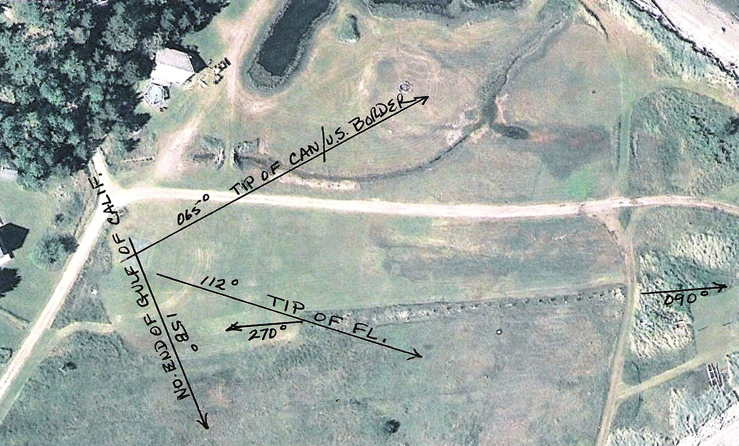
INSPIRATION PEAK LAND SURVEY
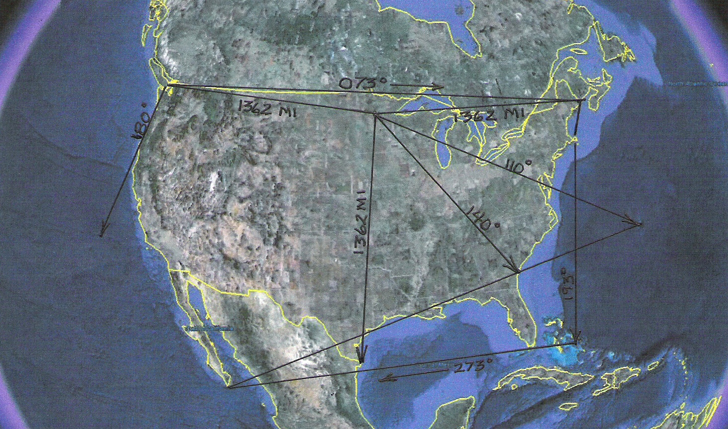
Inspiration Peak, Minnesota USA - The North American Territory As Designated by Inspiration Peak and The Newport Tower Prior to the Introduction of the Kensington Runestone.
GEOGLYPHS AT THE END OF THE 1362 MILE LONG RADIAL ENDPOINTS
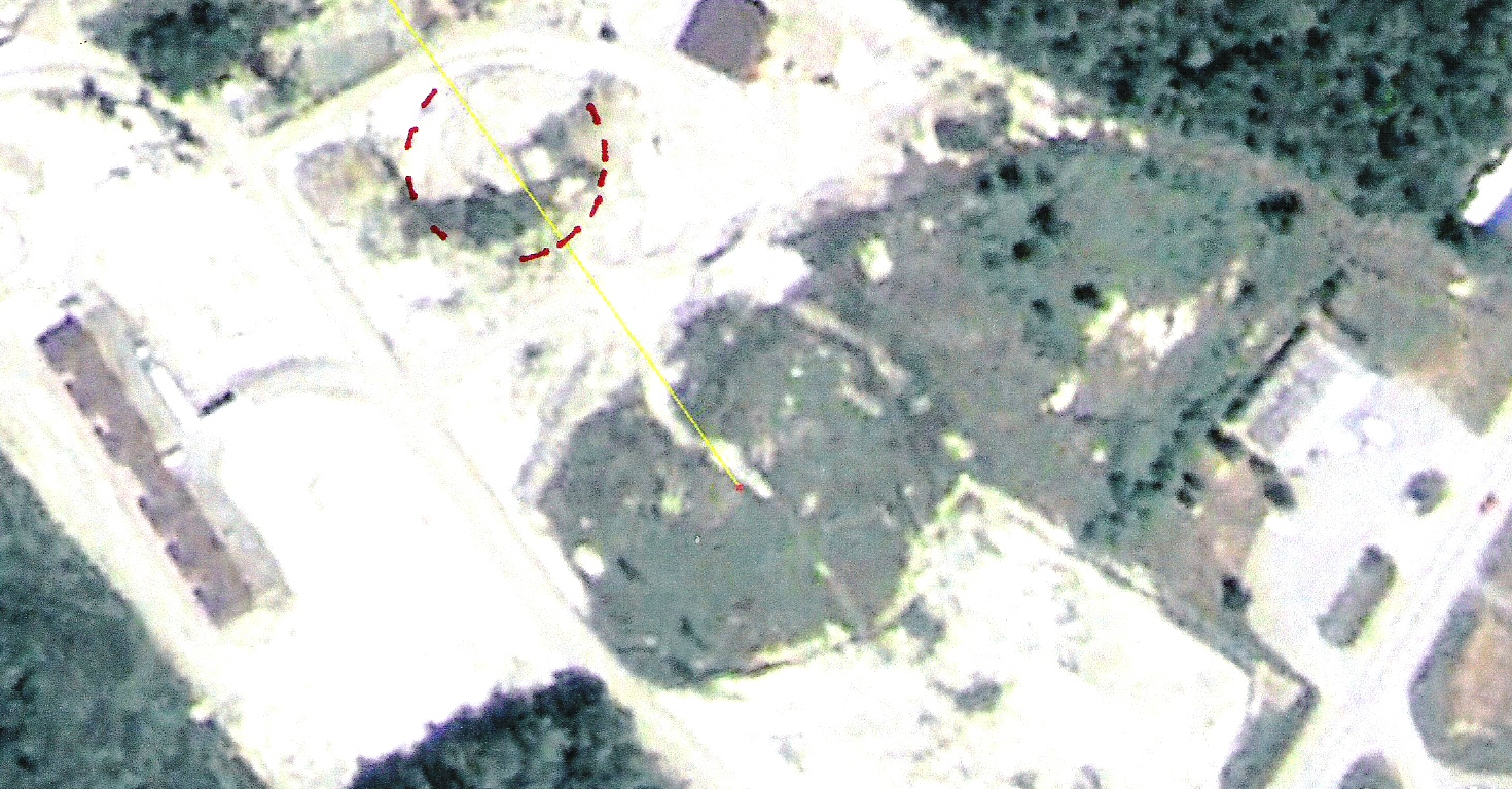
The 1362 Northwest Endpoint and Associated Square Geoglyph 48 40 26.90N 123 10 11.61W
Depicted above is the termination point of the Northwest 1362 mile long radial from Inspiration Peak. The associated square geoglyph is a survey marker validating the Northeast corner of the Northern Territory. (Later to become the United States.) This geoglyph is on Stuart Island, the last island before Vancouver Island, Canada, which is still within the US borders. Based on protocols used in constructing the four geoglyphs depicted here, it is believed that the geoglyphs were made by the same group of people that revised the North American Land Claim. It is apparent that they wanted there to be no mistake as to the territory which they claimed, and as would be proved later, were willing to fight for. Unfortunatly the landowner has since destroyed this survey marker.
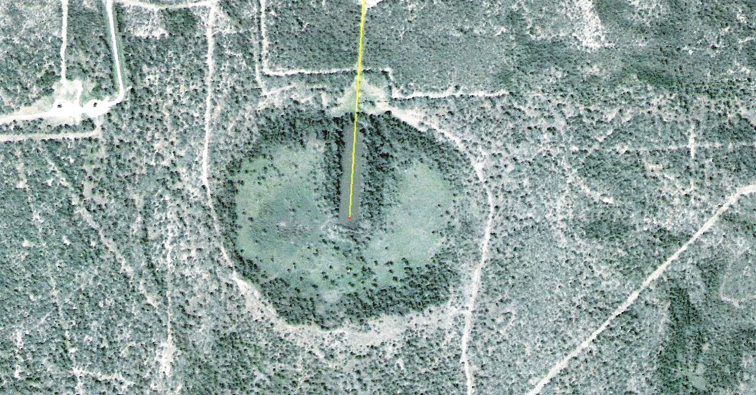
The 1362 Northeast Endpoint and Associated Geoglyph 45 07 57.09N 67 18 56.65W
Depicted above is the termination point of the Northeast 1362 mile long radial from Inspiration Peak. Unfortunately the owners of this property have not taken very good care of this geoglyph. Amazingly, this geoglyph points directly to the island of La Haute-Cote Nord, the island in the Saint Lawrence Seaway that provides the first clue, the termination point of the 013 degree radial, in solving the Newport Tower Puzzle. This geoglyph is located at the original Northern boundary of the State of Maine and the Northern Territory. The land north of here was added to the U.S. later. Unfortunatly this geoglyph has also been destroyed by the land owner.
The 1362 Mile Southern Texas Endpoint and Associated Geoglyph 26 26 33.42N 97 33 02.47W
This geoglyph requires some explanation. When this Southern 1362 mile long radial was added, after the revised North American territory was defined, it extended to within 30 miles of the Rio Grand River. As a result, up until the Mexican-American war, there had always been a dispute as to where the Southern boundary of the United States ended. After Spain had taken over Mesoamerica they claimed that the point where the southern 1362 mile long radial ended, the Nueces River, was the southern boundary of the United States. The US claimed that the Rio Grande River was the boundary between the US and Mexico. This dispute was not settled until the Mexican-American War.
THE ALL SEEING EYE
The Inspiration Peak All Seeing Eye (45 51 03.03N - 95 34 24.55W)
In the preceding photo is the glyph of the "All Seeing Eye" which is seen in Egyptian hieroglyphics, Masonic icons, and on the US one dollar bill. This glyph, and the key next to it, are of raised earth so that they will stand the test of time. This and similar glyphs are located at numerous locations around the United States as survey markers and reminders of European visitations in ancient times. The last glyph known, at this time, to have been constructed in the USA are the streets of Washington D.C. . The key glyph to the left of the eye is oriented at 360 degrees true, and points right back to Inspiration Peak.
ANCIENT ARTIFACTS FOUND IN THE USA
Several runestones have been found in the United States, most notably the Kensington Runestone in Minnesota and the Heavener Stones in Oklahoma. A runestone is typically a raised stone with a runic inscription, but the term can also be applied to inscriptions on boulders and on bedrock. The tradition began in the 4th century, and it lasted into the 12th century. Most runestones are located in Scandinavia, but there are also scattered runestones in locations that were visited by Norsemen during their exploration of North America. Ref: Keyword "runestone" - http://www.wikipedia.com .
There has been considerable debate over the age and validity of the runestones which have been found up until this time. However, as the years pass, evidence is accumulating, in quantities too large to ignore, which validates and supports the fact that there was pre-Columbian exploration in North America.
The Heavner Oklahoma Runestones
Inscription on Heavener Runestone #1
Stones similar to the Kensington Runestone have been found up and down the East Coast, in the Ohio Valley and on the Great Plains of North America. The "Heavener Runestone" of Oklahoma is a slab about 12 feet high, 10 feet wide, and 16 inches thick with runic letters spelling out the word "Gaomedat". By reversing two runes which appear to be different from the others, the inscription becomes "Glomedal", or "Glome's Valley". It could also be rendered "G. Nomedal". Nomedal is a Norwegian family name. Thanks to the efforts of Gloria Farley, the area surrounding the stone is now the Heavner Runestone State Park. The stone is now protected inside a building erected around it. The official theory is that the stone was erected as a Nordic boundary marker between 600 A.D. and 900 A.D.
Inscription on Heavener#2
The second stone, which measures 30 by 14 inches and which is 20 inches thick, shows a 12-inch, three-pronged symbol on a stem. Below it on the side surface is a small mark which proved to be a "bindrune," or combination of two runes. These markings are similar to other markings around the world which serve as geoglyphic markers. The three pronged symbol would typically point to three predetermined, and well known points, which would validate this point as having been visited by a person that was aware of the geometric protocols used by navigators of the period. The stone could provide a claim to this spot, and possibly a certain amount of land around it. Since the stone was moved and no orientation has been provided it would be difficult to determine which landmarks the originator was using to validate his claim. A similar, but more sophisticated, method of denoting a position was used in the writing on the Spirit Pond Stone described later.
Inscription on Heavener#3>
On Heavener Stone Three, a cross, a direction symbol similar to the mark on Stone #2, and an arrow appear on the stone. The symbols are 6 to 9 inches tall, appear in a triangular pattern on a stone 5 1/2 feet long. Similar survey markers have shown that each line on the marker may point to a predetermined point to further validate the stone marker. Most survey markers include an orientation line that points either North, South, or East. That marker is most likely the arrow. However, since the stone was moved it would be difficult to determine its' orientation.
The Poteau Oklahoma Runestone
The Poteau Stone
The Poteau stone, found by schoolboys in 1967, is 15 inches long. There are seven characters in a straight line, l 1/2 to 2 inches high. The runes showed very plainly because the bottom of the grooves were in a lighter colored layer of the stone, while the surface was dark. Tool marks in the grooves showed that the letters had been made with a punch, like the Heavener and Kensington Runestones. Four of the runes are duplicates of those on the Heavener Runestone, and three seemed to be variants of others on it. The Heavener Runestone lies approximetly 10 miles Southeast of the Poteau Runestone. The original sties of Heavener Runestones numbers two and three fall in a line between them.
The Shawnee Oklahoma Runestone
The Shawnee Runestone
Yet another stone was found in Shawnee, Oklahoma. Its five runes, all from the 24-rune Elder Futhark alphabet, spells out "MEDOK." Medok is similar to Madoc, the name of a Welsh prince. Welch records state that he came to America in the year 1170 A.D., then returned to Wales for ten shiploads of colonists which he led up the Mississippi River. However, the Welsh did not use third century AD Norse runes and the name Medok is not Madoc. Alf Monge studied the inscription on the Shawnee Runestone and said it was another Norse cryptopuzzle, giving the date November 24, 1024 A.D. It is this writers opinion that the persons who discovered these stones should return to the spot where they found them to find a mate. If people are finding stones, some with names on them and others with survey markings on them, it would stand to reason that there would be one of each type of stone at each location. Interestingly enough, all the stones found in Oklahoma are in close proximity to the Sulpher City Geoglyphs which confirm the existence of pre-Columbian exploration in North America.
THE MAINE RUNESTONES
One of the Spirit Pond Stones
The Spirit Pond Runestones were found in Maine in 1971. One bears a rough map of the area; the second has six lines of runic writing on one side, and ten lines of runes on the other. The inscription tells of a sudden storm and fearful men trying to save their ship from "The foamy arms of Aegir, angry god of the sea". This stone, too, has been called a hoax. The cryptologist Alf Monge believes that the stone is genuine. After reading the following dialog you will most likely come to the conclusion that the stones are authentic.
One of the Spirit Pond Stones Translated
The main reason that this stone has confounded scholars for years is that some of the writing was said to be undecipherable. Could that be because the writing is composed of 18 different ethnic origins? Study has shown that the writing on the third stone could be the names of the seamen that were shipwrecked. This is validated by the fact that the names are of various ethnic origins from the ports which the Norse ships were known to frequent. It is further validated by the fact that there appear to be approximately 40 names on the list. This is approximately the number of men known to have manned one Nordic Ship. It is also documented that their ships were not manned solely by Norsemen. The Roman Numeral date 1002 AD , in the lower right-hand corner, coincides with many other dates around North America which indicate pre-Columbian exploration of North America.
Spirit Pond Stone Position Calculated from Coordinates on the Stone.
The numbers on the stone, S10 Na 4 UMF 6, appear, by their very nature, to be coordinates of some kind. Research shows that a position on the Maine Coast can be calculated using these numbers. It was discovered that by using the early settlers archaic form of plotting a position, any position on the earth can be plotted with an accuracy of within several feet to several hundred feet. The position illustrated above was calculated prior to discovering that it lies precisely on the 090 degree bearing from Inspiration Peak. Also, the area just North of this position is named Salisbury. Curiously Stonehenge is at Salisbury England. In addition there are geoglyphs on Salisbury Beach, just north of these coordinates, which use the same protocols as European geoglyphs. The ancient mariners always provided a way to validate the correct solution to their puzzles. The Inspiration Peak 090 Degree Bearing is that double check.
The Map Depicted on One of the Stones
Portsmouth New Hampshire
Portsmouth New Hampshire is located just South of the S10 Na 4 UMF 6 Position and appears to match the map on the stone. The tip of the peninsula could have eroded away from river and tide currents. Although the three stones were found together. One stone appears to be poem, one appears to be a ship roster, and another is a map. They could each have been made for a different reason or by different persons. And again, remember that the text on runestones is misleading. It is primarily the symbols and numbers which need to be studied.
The Spirit Pond Stone Location When Discovered.
Displayed in this Plate is the position that is recorded as having been the location of the Spirit Pond Stones when they were discovered. The stones were most likely carried North to this location by the originators.
The Geoglyph Associated with Spirit Pond
This geoglyph is located a short distance North of Spirit Pond. (Shown in the preceding Plate) More geoglyphs are more than likely hidden under the tree canopy. The end points of these radials are also found in the Fort Adams Geoglyph.
LA MERICA
The first true story of the colonization of the Americas
Over 150 graphs and photos to illustrate the points made in the book.
To order from Amazon.com, or to review the contents of the book, click below.
There are stringent copyrights attached to this work. This work may not be duplicated in any
fashion, electronically or physically, in public or in private, without the written permission of
"The Faram Foundation".


 Click here for Amazon.com in the US
 Click here for Amazon.com in the UK
